


GAIN AN UNDERSTANDING OF UNDERWATER TERRAIN TO SUPPORT NAVIGATION AND DREDGING ACTIVITIES AND LAND PROJECTS
We conduct bathymetric surveys using an echo sounder attached to a survey vessel. We can utilise uncrewed survey vessels to improve project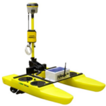 efficiencies and reduce mobilisations.
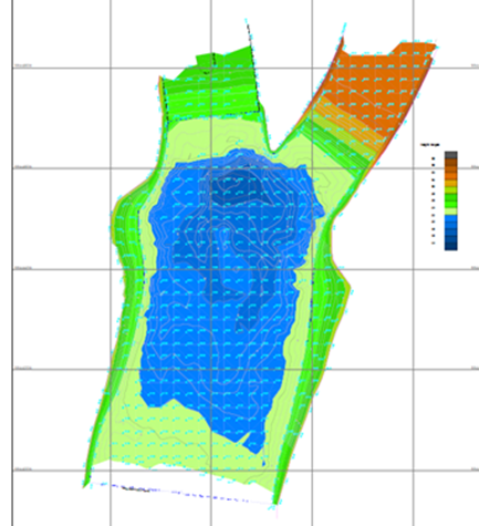
The vessel covers the area with a series of long and cross profiles from which a dense regular grid of levels is generated. Our surveys use highly accurate GNSS (GPS) systems to link each measured distance to a particular depth on the map.
Data is delivered to the customer as an elevated model to inform decisions for nearshore and land-based projects.
Survey methods can also include:
- Multi-beam survey
- Single-beam surveying
- Acoustic Doppler Current Profiler (ADCP)
- Sub-bottom profilers
Recent projects have been undertaken to determine the water volume of several inshore reservoirs with a view to dredging for increased storage capacity and improved generation.
Delivered by UTEC
UTEC is one of the largest global independent surveying companies providing services across many industrial sectors including renewables, oil and gas, telecommunications, civil engineering, construction, petrochemical, and minerals.

Integrate this product
Acteon can also offer an integrated project management service. This involves managing the activities of one or more of our companies on a customer’s behalf and providing a single point of contact for all aspects of project management.

GEO-SERVICES BROCHURE
Discover more about our solutions to real customer challenges and explore our full range of services to help you achieve project efficiencies.
Similar products and services
-
Experienced offshore teams supported by decades of onshore project management and survey...
-
The communications hub provides the connectivity required for successful delivery of any...
-
Wide range of survey services for the civil, construction, energy, rail, infrastructure...
-
GEOROV is a rov-compatible seabed cone penetration test (cpt) and sampling system. The...