


Geospatial, dimensional control and digital twin
CAPTURE, ANALYSIS AND APPLICATION OF HIGHLY ACCURATE GEO-REFERENCED DATA
Specialising in 3D asset management software solutions, geospatial surveys, dimensional control and telecoms services, we capture, process and deliver spatially referenced data across the lifecycle to optimise projects.
By working in partnership with Acteon, contractors and operators benefit from:
- Fast, and accurate surveying techniques performed onshore, reducing the time and costs associated with multiple visits to offshore sites, resulting in lower risk and significant health and safety improvements with fewer mobilisations.
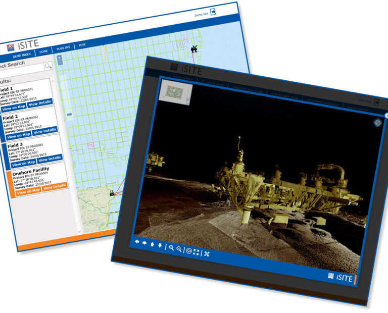
- Remote management and access to assets from their desktop via Acteon’s proprietary 4D virtual asset management solution iSite, driving down the cost of offshore planning and communication.
- Reduced personnel on board (POB) without compromising safety; we have reported that 89% of iSite users see a reduction in offshore personnel days.
- Automated data processing and calculations to remove any incidences of human error when handling or manipulating data, whilst speeding up the overall time to process the data resulting in time and cost savings.
Solving your most pressing challenges
Acteon helps customers to reduce the time from data collection to results.
Acteon solution
Acteon provides a platform for better decision-making allowing customers and contractors to have access to the data they need to plan, evaluate and problem solve safety, environmental and risk scenarios.
Proof points
- We develop smarter workflows creating task hierarchies that improve efficiency and enable project managers to see the status or share information on a project in one place.
- We use our domain knowledge to design systems that address the specific needs of the project and/or the requirements of the environment.
- We utilise multi-disciplinary teams, across multiple locations, to remotely collaborate and contribute to a project through a single interface.
- Seamless sharing of information and documentation with a secure web link eliminates the need to download new software or adapt or integrate with an IT tech stack.
Acteon solution
Acteon generates quantifiable survey information using an approach focused on due diligence, project review and assessment and active discussions with the customer to ensure we have a full understanding of the scope of works and the work environment, and that the survey requirement is undertaken efficiently and to plan, avoiding the need for any revisits.
Proof points
- We use latest technology including GPS, total stations, laser scanners and mobile solutions to capture data faster, minimise travel costs, minimise environmental impact and increase operational safety.
- Have a strong track record in calibration and offset surveys with 30 projects completed within the last three years: 11 vessel calibrations and 19 surveys of stingers, piles, trees and fast frames.
- We support equipment replacements or new fabrications on brownfield projects working to the required tolerances, up to sub-millimetre.
Acteon solution
Acteon provides a single source survey contract which will consider the most efficient way of undertaking the task leveraging the right sensor/equipment to meet the specification.
Proof points
- We offer an array of survey technology solutions including ground (laser, GPS, total station, mobile mapping unit), water (echo sounder, Blueview, UAV), and air-based sensors (drones with LIDAR and Camera payloads) to support all survey needs under a single contract.
- We manage projects and logistics across the globe to provide a single point of contact for logistics.
- We have local knowledge of equipment transfer or hiring in a specific country, medical/safety requirements for operation in-country and utilise local agents where required.
- Our latest sensors and processing software streamlines the end-to-end process of digital data generation and intuitive processing techniques are utilised to automate the process.
Read the case study:
Radar surveys to increase efficiency on Berwick Bank wind farm development
Acteon solution
Using our in-house digital twin solution, iSite, Acteon can consolidate survey data, transforming it into a visual asset management solution which can be customised and accessed by all stakeholders via cloud servers.
Proof points
- The consolidation of existing survey information leverages current datasets without the need for costly re-acquisition exercises.
- Consolidation of key datasets into an intuitive visual interface provides a holistic view of the worksite, driving informed decisions.
- 52% of iSite users surveyed recorded significant cost savings, due to reduced offshore working. 48% stated they utilise the iSite daily for more effective communication and project planning.
- Our digital twin solutions have been active in the market for over 10 years, supporting our customer base.
Read the case study:
Subsea 3D Laser Survey
Acteon solution
Acteon operates with internationally recognised standards to meet the needs of the various markets that we work in, and our customers required compliance standards.
Proof points
- We are accredited to the following standards: ISO 9001:2015, ISO 14001:2015, ISO 45001:2018, RISQS, UVDB.
- We actively monitor training and staff competency to ensure the right skilled individuals are assigned to our projects.
- Over the past three years we have had zero lost time injuries, zero environmental incidents and zero dangerous occurrences which is a testament to our robust policies and procedures applied across our geospatial, dimensional control and digital twin operations.
- When deciding which technology to use, safety is our top priority; for example, we can avoid working from height by using contactless data acquisition methods.
A proven suite of products and services
We provide fast, accurate surveying techniques to reduce the time and costs associated with multiple visits to sites.
Geo-services specialisms
Offering a single point of contact to drive project efficiency; our focus is to provide highly accurate geo-referenced data to increase overall project efficiencies.