


Acteon Equipment sales & rental Electronics & Tooling ROV SensorsInertial Navigation Systems (INS)
Inertial Navigation Systems (INS)
Return to ROV SensorsSearch products
X Products selected
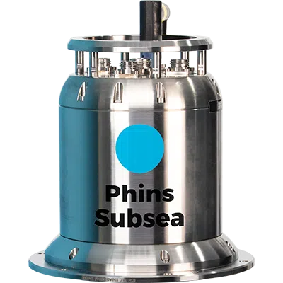
iXblue PHINS 6000 Subsea
PHINS 6000 is a subsea inertial navigation system (INS) providing position, true heading, attitude, speed, depth, and heave for deep water operations.
PHINS 6000 is a subsea inertial navigation system (INS) providing position, true heading, attitude, speed, depth, and heave for deep water operations. Its high-accuracy inertial measurement unit is coupled with an embedded digital signal processor that runs an advanced Kalman filter. PHINS DVL Ready is pre-assembled and pre-calibrated with a Doppler velocity log version making the system easy to install and ready to use for more precise navigation.
Features:
- All-in-one high-accuracy 3D positioning with heading, roll and pitch
- FOG, unique strap-down technology
- Multiple aiding available: (DVL, USBL, LBL, RAMSES, GPS, depth sensor)
- Options: DVL or RAMSES coupling
- Ethernet, web server (GUI)
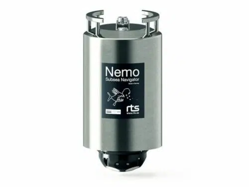
RTS Nemo Subsea Navigator
The RTS NEMO Subsea Navigator is a combined INS and DVL solution for water depths up to 4000m. The unit is purpose-built for ROV navigation and features state-of-the-art field proven components from renowned subsea manufacturers iXblue, Nortek and RTS.
NEMO has been designed for maximum reliability with such features as maintenance-free power drop-out protection, titanium housing and connectors and FOG technology. NEMO comes ready-calibrated in a robust single housing. The remarkably compact size and low weight of the NEMO and customizable mounting brackets makes it ideal for placement on a large range of ROVs from observation-class to work-class.
- All-in-one Navigation System
- Fully calibrated (one housing)
- Compact size
- Titanium housing
- iXblue and Nortek Inside ®
- INS & DVL in separate watertight compartments
- Maintenance-free FOG technology
- Power drop-out protection (battery-free)
- 4000m depth rating
- Current Profiler
- Spectrum Analyzer
- Web interface for direct control and monitoring of DVL and INS
- Engineered for extreme reliability
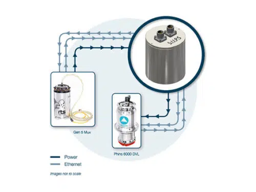
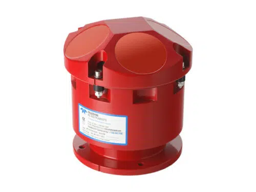
Seatronics S.U.P.S
Designed to reduce survey sensor downtime during ROV power outages, the Seatronics Uninterruptible Power Supply (SUPS) is capable of maintaining power to an Inertial Navigation System or ancillary sensor system for up to 100 minutes. The result of a simple DC trip could result in the mandatory realignment phase being conducted; taking up to 45 minutes, the SUPS system would remove this lost time.
Designed to be fully compatible with all standard survey sensors:- ROVINS, PHINS, RDI DVL and with seamless integration with the Gen 5 Multiplexer. Internal batteries conform to UN3480 requirements to allow for safe shipping.
The design features a web-based reporting tool for all performance aspects of the design which includes Battery capacity and time remaining reported along with current, voltage, temperature and overall system status.
- 4000 MSW rated subsea housing
- 24V DC operation
- UN 3480 approved battery makes shipping lithium content easier
- Gigabit Ethernet
- Compatible with RTS Gen5 MUX
- Voltage, current, power and temperature monitored
- Capacity and status reporting via Ethernet
- Under and over voltage protection
- Temperature and current surge protection
- Short circuit/reverse polarity protection
- Battery condition/replacement indicator
- Secondary output for DVL, Digiquartz, MiniSVS etc.
Sonardyne Fusion 2 INS & LBL Software
Sonardyne Fusion 2 INS & LBL Software
One system from which you can control all of your subsea Long BaseLine (LBL), Sparse LBL and SPRINT Inertial Navigation System (INS) projects. Introducing Fusion 2 – our most powerful, most configurable and most efficient navigation and positioning software ever.
- Sonardyne’s fastest, most capable survey and construction software system yet
- A single solution for your LBL and aided SPRINT INS projects
- Less vessel hardware and less interfaces
- Intuitive and customisable user interface; less training needed
- Supports real-time SLAM calibration of sparse LBL arrays
- Optimised for new 6G+ and Wideband 3
Gone is the need to operate two independent software and hardware systems to control your 6G LBL and SPRINT INS. Fusion 2 does it all in a single interface, designed from the ground-up with intuitive workflows so there’s less to learn. It also means reduced set-up time, reduced interfacing and reduced onboard hardware.
For the first time Fusion 2 enables seabed transponders to be SLAM calibrated in real-time for easier and faster Sparse LBL operations. The UI can be customised using docks, and includes light and dark themes. And by embedding sensor data with high update navigation ranging data, there’s no more interruptions to positioning updates at critical moments.
With Fusion 2, you’ll begin to see the benefits even before your project teams head offshore. Acoustic and INS projects can be configured and checked in the office prior to vessel mobilisation – saving you time, streamlining procedures and helping you to further de-risk operations.
Sonardyne SPRINT System
SPRINT is an acoustically aided Subsea Inertial Navigation system for subsea vehicles. SPRINT makes optimal use of acoustic aiding data from acoustic USBL and LBL positioning and other sensors such as Doppler Velocity Log (DVL) and pressure sensors. This improves position accuracy, precision, reliability and integrity while reducing operational time and vessel costs. The system extends the operating limits of Ultra- Short BaseLine (USBL) and can dramatically improve the operational efficiency of Long BaseLine (LBL). The new third generation SPRINT unit offers power pass-through to aiding sensors, reducing cabling and interfacing complexity.
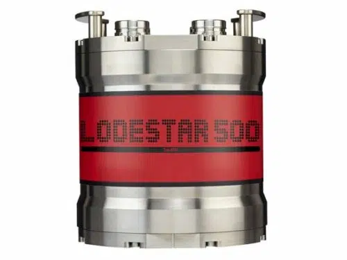
SPRINT INS shares the same hardware platform as Lodestar AHRS and is a combined AHRS (Attitude Heading Reference System) and AAINS (Acoustically Aided Inertial Navigation System). Running both the AHRS and INS algorithms concurrently allows inertial navigation to start or restart instantaneously on receipt of a position update as the AHRS seamlessly provides orientation to the INS on start-up. This avoids the lengthy ‘alignment’ period common to other INS systems. Thereafter, the separate AHRS and INS computed orientation are autonomously monitored as an indication of system health.
All AHRS and AAINS computations are performed within the Lodestar, making the system robust and resilient to communications issues. Lodestar maintains a rolling 15 day backup of all real time navigation and raw data on an onboard SD card which can be retrieved if required. Coupled with concurrent logging of all data by the topside software, data integrity is ensured.
- Popular for navigating ROVs and AUVs
- Speeds up operations – saves you vessel time
- Small, lightweight and easy to install
- Track record spanning more that 10 years
- Range of performance levels to suit your task
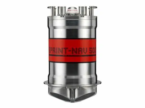
Sonardyne SPRINT-Nav 500
SPRINT Nav is an all-in-one subsea navigation instrument for underwater vehicles. t combines Sonardyne’s SPRINT INS, Syrinx DVL 600 kHz (Doppler Velocity Log) and high accuracy intelligent pressure sensor in a single housing that is one of the smallest combined inertial navigation instruments on the market.
The unit is comprised of three high grade Ring Laser Gyros (RLG) and accelerometers. These ultra-reliable sensors are used also for safety critical navigation by the majority of the world’s large commercial aircraft and do not require factory recalibration over the product’s lifespan.
SPRINT-Nav’s dual algorithm capability is unique in the market and allows for simultaneous use from one instrument, e.g. AHRS plus DVL for ROV piloting, INS plus DVL for survey operations.
The SPRINT and Syrinx components can be operated as standalone sensors, independently of one another depending on the need. SPRINT-Nav is calibration free.
With power-pass-through, aiding sensors can be powered directly, reducing cabling cost and complexity. Sensor offsets are rigid and very accurately known, helping to reduce systematic errors in lever arm measurements. The pressure sensor module can be removed for calibration or repair without incurring downtime.
Each Syrinx transducer is fitted with a full depth rated water block to ensure protection of the internal components.
- World’s highest performing hybrid navigator
- All-in-one turn-key solution
- Dual concurrent AHRS, INS and
- DVL output capability for multi-use
- Instantaneous INS initialisation from AHRS with no alignment
procedure required - Dual AHRS & INS algorithms enabling internal health check of orientation
- Highly optimised SWaP
- Proven long life and high MTBF inertial sensors from trusted longterm US supplier
- Remote diagnostics and performance verification
- Fully water blocked DVL endcap protecting internal electronics
- 0.4–175 m bottom track operating range
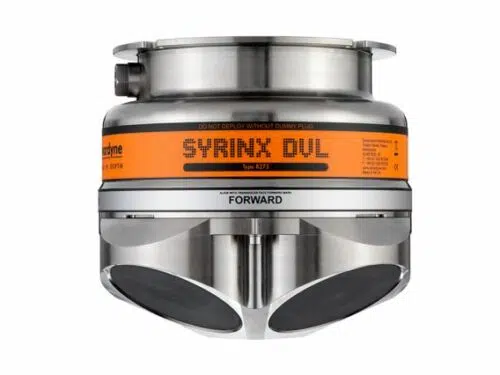
Sonardyne SYRINX
Syrinx is a 600 kHz Doppler Velocity Log (DVL) for surface and subsea vehicles. The Syrinx DVL is a class leading Doppler Velocity Log that builds on Sonardyne’s existing product range of acoustic instrumentation by bringing to market a high integrity, high performance instrument.
- Class leading 600 kHz DVL combining the benefits of 300 and 1200 kHz instruments in one
- Reliable adaptive bottom lock
- Capsule case design built around field proven USBL array capsules developed over last 30 years
- Concurrent Ethernet and serial connectivity
- Individually replaceable transducers
- On-board DVL Manager web interface for configuration and diagnostics
- Standard 4000 m titanium housing for Work Class ROVs
- Full linear signal processing
- Up to 25 Hz ping rate
- 0.4 to 175 m operation range
- Tight integration to Sonardyne SPRINT INS, providing unmatched DVL aided navigation even in challenging bottom lock conditions
- Internal bulkhead prevents water ingress if a transducer is damaged
Syrinx can be used as a standalone navigation instrument or can be integrated into Sonardyne’s SPRINT system or other 3rd party navigation systems.
This new DVL provides the best of both worlds in a single unit available in depth options of 4,000 and 6,000 metres. With a large altitude range and high precision at all altitudes, this combines the best of 300 and 1200 kHz DVLs.
Syrinx utilises both Doppler and Correlation technology to gain performance advantages in environments where each technology is best suited.
Processing techniques have been refined to avoid any loss in output measurements including undulating and sharp roll off terrain of any type. The instrument has been tested over terrains with near vertical gradients to ensure velocity estimates are always provided, even when individual beam data can show vast differences in altitude.
Adaptive signalling techniques utilise the best signal type for the environment and terrain, this allows both low and high altitude class leading performance.
Syrinx allows users to simultaneously output data of different formats, so you can provide the ROV crew with one data format and your survey crew another. This reduces the requirement of more than one DVL on board the ROV, saving on weight and costs.
Sonardyne have developed the transducers to be singularly interchangeable, dramatically reducing maintenance costs and times.
An internal bulkhead is fitted to protect the main chamber (containing the internal electronics) from water ingress should a transducer become badly damaged.
Teledyne RDI Explorer Doppler Velocity Log
Teledyne RD Instruments’ Explorer is the newest addition to our family of proven Doppler Velocity Log (DVL) products.
- A versatile package with significantly reduced size and weight
- Highly efficient, low power, remote electronics designed to fit in a 4” ID hull
- Open architecture design capable of communicating with other onboard sensors, such as pressure, GPS, CTD, Gryro and magnetic compass
- Upgradable to include ADCP (Acoustic Doppler Current Profiling) capability
- Teledyne RDI’s proven bottom-tracking algorithms and reputation as the leader in DVL technology, service and support
The new Explorer DVL is the long awaited solution to high quality navigation aboard small underwater platforms such as AUVs, gliders, disposable vehicles, inspection class ROVs, and diver platforms. The Explorer DVL has been designed specifically for this next generation of shallow water platforms requiring Teledyne RDI’s proven precision and reliability in a compact and versatile package.
The highly compact and versatile Explorer DVL provides: A versatile package with significantly reduced size and weight Highly efficient, low power, remote electronics designed to fit in a 4″ ID hull Open architecture design capable of communicating with other onboard sensors, such as pressure, GPS, CTD, Gyro and magnetic compass Upgradable to include ADCP (Acoustic Doppler Current Profiling) capability Teledyne RDI’s proven bottom-tracking algorithms and reputation as the leader in DVL technology, service and support.
Teledyne RDI Workhorse Navigator Doppler Velocity Log
Traditional underwater navigation systems provide only periodic position update that can leave you uncertain as to where your ROV/AUV, or vehicle is located.
Teledyne RD Instruments revolutionary Workhorse Navigator DVLs fill in these gaps with high rate, high precision navigation data, using patented BroadBand bottom tracking algorithms. Now you can feel confident that you know your exact underwater location at all times – even in deep water.
Teledyne RDI’s DVLs can also be customized to meet your specific mission requirements.
- Patented BroadBand processing technology, providing users with both short and long-term high-precision velocity data
- Reliable and accurate high-rate navigation and positioning data
- Proven bottom-detection algorithms, and single-ping bottom location,for robust and reliable bottom tracking over indeterminate terrain
- Superior low-altitude bottom-tracking capability
- Real-time current profiling data
- Full suite of sensors including:
- Bottom track velocity
- Water track velocity
- Altitude: 4 individual measurements
- Error velocity (data quality indicator)
- Temperature
- Heading/Tilt
- Acoustic echo intensity
- Pressure and depth (optional)
- Current profiling (optional)