


Gyro Compasses
Return to PositioningSearch products
X Products selected
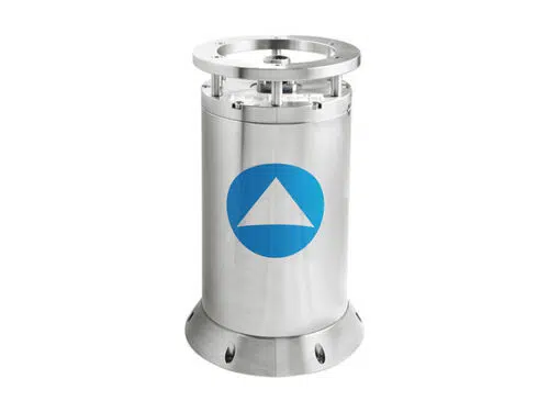
iXblue Octans 3000
OCTANS 3000 is a subsea survey-grade gyrocompass and complete motion sensor for water depths up to 3,000 m.
OCTANS 3000 is a subsea survey-grade gyrocompass and complete motion sensor for water depths up to 3,000 m. Based on iXBlue’s fiber-optic gyroscope (FOG) technology it outputs heading, roll, pitch, heave, rate of turn and acceleration. OCTANS 3000 can be easily upgraded to full INS mode (i.e. ROVINS).
- Complete gyrocompass and motion sensor
- smart HeaveTM
- Fiber-optic gyroscope (FOG), unique strap-down technology
- Ethernet, web-based man-machine interface (MMI)
- Titanium made, small, portable plug and play system
- Optional full featured inertial navigation system
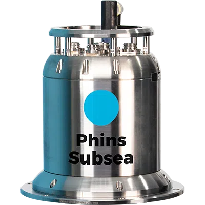
iXblue PHINS 6000 Subsea
PHINS 6000 is a subsea inertial navigation system (INS) providing position, true heading, attitude, speed, depth, and heave for deep water operations.
PHINS 6000 is a subsea inertial navigation system (INS) providing position, true heading, attitude, speed, depth, and heave for deep water operations. Its high-accuracy inertial measurement unit is coupled with an embedded digital signal processor that runs an advanced Kalman filter. PHINS DVL Ready is pre-assembled and pre-calibrated with a Doppler velocity log version making the system easy to install and ready to use for more precise navigation.
Features:
- All-in-one high-accuracy 3D positioning with heading, roll and pitch
- FOG, unique strap-down technology
- Multiple aiding available: (DVL, USBL, LBL, RAMSES, GPS, depth sensor)
- Options: DVL or RAMSES coupling
- Ethernet, web server (GUI)
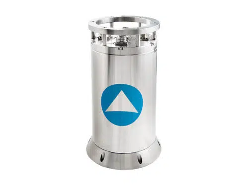
iXblue ROVINS
ROVINS is a combined survey-grade full featured Inertial Navigation System (INS) for water depths up to 3,000m.
ROVINS is a combined survey-grade full featured Inertial Navigation System (INS) for water depths up to 3,000m. Designed specifically for offshore survey and construction works, ROVINS improves the efficiency of all operations where accurate position, heading and attitude are key benefits.
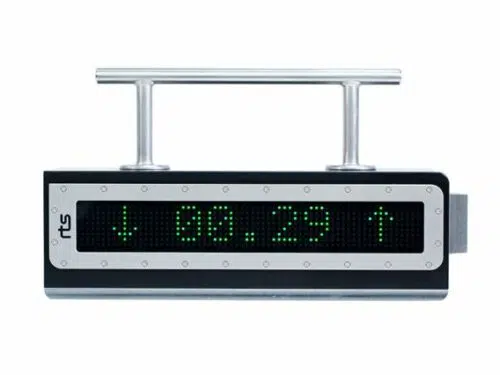
OceanTools OceanDISP
The OceanTools OceanDISP is a unique subsea display unit for subsea gyro-compasses and attitude sensors.
- ROV-friendly AND Diver-friendly
- Bright RED or GREEN high visibility display LED options
- Programmable power-on then sleep mode – extends battery life
- Programmable data-input telegrams – works with any subsea gyro
- Programmable light-activated power-on
- High performance at a very reasonable price
- Standard depth rating 1000m – deeper options available
It contains some advanced, innovative, features including: OceanDISP may be switched-on subsea by shining an ROV light or divers torch at it. Light detectors then “wake up” the remainder of the electronics. This feature may be enabled or disabled and is designed to extend the life of the subsea battery pack supplying the system.
The time that it remains on for can be set in 10 minute intervals. This is important if using modern, fibre optic gyrocompasses that have far shorter run-up times than older, slower, mechanical gyrocompasses. A MiniFOG will show accurate data within 10 minutes of power-up whereby an older mechanical gyro may take over 45 minutes to run-up.
OceanDISP works with almost every underwater gyro and attitude sensor- not just with OceanTools MiniFOG units. If a data-input containing multiple parameters (i.e. heading, pitch, roll etc) is fed to OceanDISP it will display each parameter for a user-selectable time before displaying the next parameter.
OceanTools OceanDISP 2
The OceanDISP-2 is a powerful light-activated subsea display unit utilising high visibility LEDs.
Data from a wide range of inputs can be displayed, including tilt sensors, gyrocompasses, pressure, temperature and flow sensors.
- 1000m to 4000m depth rated variants
- Available with red or green LEDs
- Programmable ‘wake-up’ and ‘sleep’ periods
- Displays data from RS232 or RS485 input
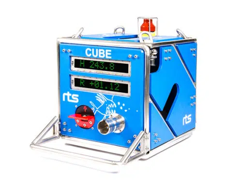
RTS CUBE
The RTS CUBE is an advanced self-contained subsea instrument package for monitoring heading, pitch, roll, depth and other user-specified parameters. The unit is scalable and can be configured as a straightforward battery-operated gyro with subsea displays or as a complex logging solution for a host of different sensors.
Examples of applications:
- Monitoring heading and inclination during descent and deployment of subsea structures
- Monitoring differential pressure inside suction anchors during deployment to avoid implosion
- Alignment and placement of pipes
- Wellhead installation
- Long term monitoring of subsea installations with automated wake-up and sleep functionality
- Post installation monitoring
The system can provide the user with live data and graphical displays of the required parameters (and optional video) via an acoustic modem or hot stab connection. This will aid the user in decision-making during critical operations and make sure specified tolerances and safety requirements are upheld. The collected CUBE data is supplied as a deliverable and can be replayed post-operation.
The CUBE consists of a frame containing system controller and logger, gyro, subsea displays, battery, acoustic telemetry, ROV-operated switch, ROV hot stab and optional auxiliary sensors.
- Remote configuration
- 32Gb Internal logger
- Intuitive control and display software
- High accuracy
- Robust construction
- Sensor flexibility
- ROV connection
- Advanced subsea display features
- External sensor capabilities
- Remote system startup (air and water)
- Tailored surface logging software
- Simple setup
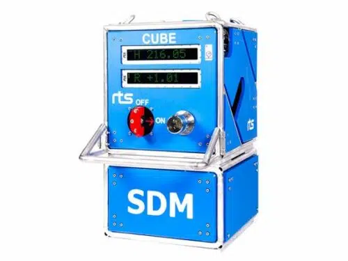
RTS CUBE SDM
The RTS CUBE SDM is a self-contained monitoring solution for subsea structures. It is used during the deployment and installation phase but can also be utilized for long-term monitoring to ensure structure stability and position.
In addition to monitoring heading, deflection and suction can pressure, the system can also provide the user with live video and a number of optional sensors. Based on a proven track record the RTS CUBE SDM is the second generation of SDM systems and offers unparalleled performance and control during critical operations.
- Real-time comprehensive structure monitoring
- Software for presentation, control and calibration
- Logging and time-stamping of all sensor data
- Wireless system testing and logging
- Real-time tide compensation (RTC)
- Robust and compact construction
- ROV connection
- Sensor choice flexibility
- Data output for third party software
- Simple setup
- Engineered based on proven track record
RTS Level
The RTS LEVEL is a high-precision one-axis inclinometer for ROVs and divers. By utilizing technology from the RTS TEXT subsea display the unit delivers unparalleled visibility and is capable of 40+ hours of continuous subsea operation per charge cycle.
The unit also features an optional external input which can interface up to two sensors and display data in user-specified intervals. The RTS LEVEL comes standard as a one-axis inclinometer but can also be upgraded to provide the user with +/- 60 degree range in two axis (pitch and roll). Configuration is performed by the operator via cable or radio, making for easy on-the-fly modifications or switching of sensors.
- Excellent visibility
- Accuracy of 0,1 degree
- 40+ hours battery life
- +/-60 degree range
- One or two axis models
- Robust construction
- External sensor input option
- 1500 MSW depth rating
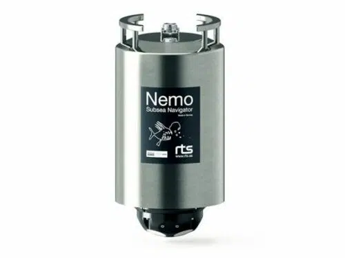
RTS Nemo Subsea Navigator
The RTS NEMO Subsea Navigator is a combined INS and DVL solution for water depths up to 4000m. The unit is purpose-built for ROV navigation and features state-of-the-art field proven components from renowned subsea manufacturers iXblue, Nortek and RTS.
NEMO has been designed for maximum reliability with such features as maintenance-free power drop-out protection, titanium housing and connectors and FOG technology. NEMO comes ready-calibrated in a robust single housing. The remarkably compact size and low weight of the NEMO and customizable mounting brackets makes it ideal for placement on a large range of ROVs from observation-class to work-class.
- All-in-one Navigation System
- Fully calibrated (one housing)
- Compact size
- Titanium housing
- iXblue and Nortek Inside ®
- INS & DVL in separate watertight compartments
- Maintenance-free FOG technology
- Power drop-out protection (battery-free)
- 4000m depth rating
- Current Profiler
- Spectrum Analyzer
- Web interface for direct control and monitoring of DVL and INS
- Engineered for extreme reliability
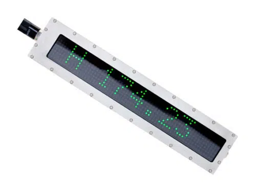
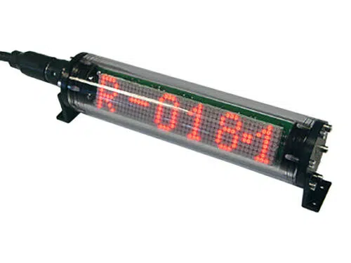
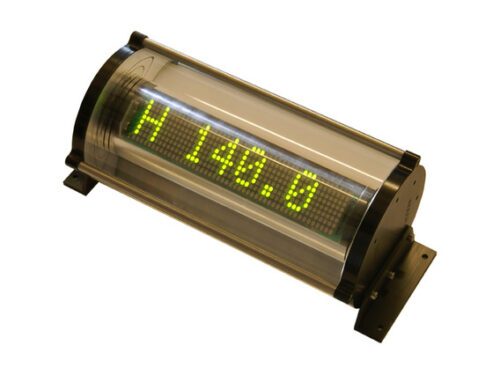
RTS TEXT
Precision visibility for subsea applications. The new RTS Subsea Display features leading edge functionality and sought after improvements for displaying information subsea.
The RTS Engineering team introduces a unit that will provide unparalleled visibility, flexibility and up to one-tenth of the power consumption of existing product solutions. Features such as automated light sensitive startup, bar graph display, limit value indication and customized colors supplies the operator with more indepth information for more effective decision-making. Also, the compact design allows for a wide range of applications while still maintaining 4k ocean depth rating.
- High visibility
- Low power consumption
- Full RGB LED
- Flexible interface
- Adjustable colors and intensity
- 4000 MSW depth rating
- Compact construction
Sonardyne 6G Lodestar Gyro Compatt
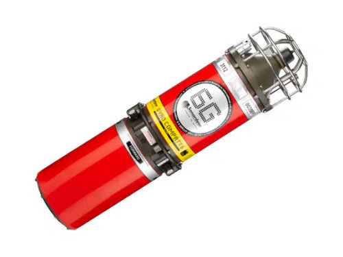
Sonardyne 6G Lodestar Gyro Compatt
The Lodestar GyroCompatt (LGC) integrates Sonardyne’s Wideband® acoustic positioning and Lodestar Attitude and Hearing Reference Technology (in one small, highly versatile and robust instrument). This provides high update rate wireless attitude, heading, heave, surge, sway, pressure, SV and acoustic positioning of any subsea object.
Compatible with USBL and LBL positioning systems, the Lodestar GyroCompatt product family provides real time motion data for structure deployment via the integrated high speed acoustic modem.
- Incorporates Sonardyne’s 6G® Technology
- Incorporates Sonardyne’s Wideband®2 signal Technology
- Sonardyne Wideband® acoustic positioning transponder and Lodestar AHRS unit in a single subsea housing
- Rechargeable 20 hour internal battery pack; option for external power
- Acoustic and manual ROV On/Off switch for Lodestar AHRS
- Upgradable to LBL aided INS
- Sonardyne Wideband® and Kongsberg HPR 400 compatible
- Autonomous data logging mode (sensor data and ranges)
- Faster command and configuration
- Simultaneous ranging and sensor data recovery in one transmission
- Integrated sound speed and pressure sensor with an additional port for auxiliary sensors
- Real time diagnostics on range measurements for quality control
- High speed acoustic modem
- Compact size for ease of handling and ROV deployment/recovery
- Data telegram output and 24 V available for ROV displays
- Lodestar IMO certifie
The internal high capacity rechargeable battery pack enables quick charge times and up to 20 hours of continuous operation with the ability to turn the gyro on and off to save battery life giving over two months of transponder life. The instrument is small and light enough to be ROV installed and a mechanical stab enables precision alignment to any structure.
Applications
Structure position and orientation can be accurately determined during lowering, set-down and as-built surveys. Using the Lodestar GyroCompatt 6 for metrology delivers the measurements required for pipe-end coupling.
The stab, gyro and transducer are pre-aligned and this speeds up spot measurements as only single observations are required.
Autonomous logging negates the need for a vessel and ROV to be on standby taking measurement during long term settlement observations.
Modular construction allows for upgrade and service access to the transponder module.
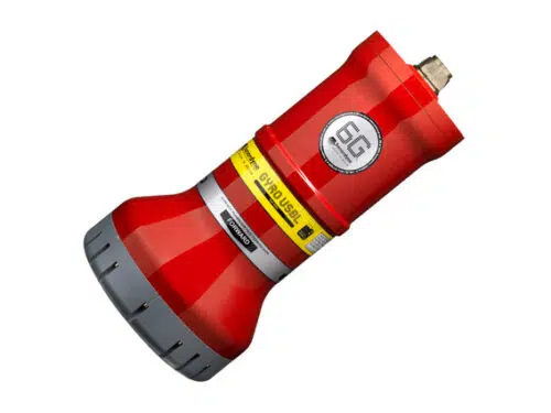
Sonardyne Lodestar GyroUSBL
Lodestar GyroUSBL combines a Sonardyne 6th (6G®) generation high performance HPT USBL transceiver and a Lodestar Attitude and Heading Reference System (AHRS) / Inertial Navigation System (INS) in the same mechanical assembly.
The instrument comes in three mechanical variants; two standard GyroUSBLs that differ by the use of the HPT component (GyroUSBL 8084-000-0445 and 8084-000-0447) and one inverted version (GyroiUSBL 8084-000-7535).
- Transceiver and Lodestar AHRS / INS offering high performance
- Available in two versions; standard and deepwater optimised
- Calibration free offering rapid set-up
- Class leading system precision and accuracy
- Sonardyne Marksman, DP-INS and Ranger 2 compatible
- Water-blocked transducer array protects electronics in the event of damage
- Compatible with Sonardyne’s through-hull, over-the-side and stem tube deployment systems
With the AHRS / INS in fixed mechanical alignment to the USBL’s acoustic array, the Lodestar GyroUSBL can be quickly deployed without need for a USBL calibration to determine the alignment of the ship’s motion sensors to the acoustic transceiver. For certain applications, this can enable significant savings in vessel time and operational costs.
The HPT transceiver component of the instrument utilises the latest Sonardyne Wideband®2 signal processing and is fully compatible with other products in the new Sonardyne 6G® equipment range.
Lodestar is tightly integrated into the USBL system providing power and communications to the HPT transceiver and embedded highly accurate time-stamping of all motion and acoustic data. This enables unparalleled precision and accuracy of position estimation by removing many of the sources of error associated with all USBLs such as lever arm offsets, pole bending, and ship flexing.
In addition, because many of the system parameters are now fixed, no USBL calibration is required during installation so the system is easier to install and set-up. Precision of better than 0.3% of slant range is achievable out of the box, or a one-off calibration can push this figure to less than 0.1% of slant range, depending on array type.
Manufactured in Aluminium-Bronze the Lodestar GyroUSBL is ideally suited for short term temporary installations on vessels of opportunity using through-hull or over-the-side poles. It is also ideal for permanent installation on flexible stem tubes.
In case of operational damage to the USBL transducer array, all electronics are robustly protected behind a double-sealed, pressure-resistant bulkhead. This ensures that if the transducer face is breached, the Lodestar and acoustic transceiver do not flood.
Sonardyne SPRINT System
SPRINT is an acoustically aided Subsea Inertial Navigation system for subsea vehicles. SPRINT makes optimal use of acoustic aiding data from acoustic USBL and LBL positioning and other sensors such as Doppler Velocity Log (DVL) and pressure sensors. This improves position accuracy, precision, reliability and integrity while reducing operational time and vessel costs. The system extends the operating limits of Ultra- Short BaseLine (USBL) and can dramatically improve the operational efficiency of Long BaseLine (LBL). The new third generation SPRINT unit offers power pass-through to aiding sensors, reducing cabling and interfacing complexity.
SPRINT INS shares the same hardware platform as Lodestar AHRS and is a combined AHRS (Attitude Heading Reference System) and AAINS (Acoustically Aided Inertial Navigation System). Running both the AHRS and INS algorithms concurrently allows inertial navigation to start or restart instantaneously on receipt of a position update as the AHRS seamlessly provides orientation to the INS on start-up. This avoids the lengthy ‘alignment’ period common to other INS systems. Thereafter, the separate AHRS and INS computed orientation are autonomously monitored as an indication of system health.
All AHRS and AAINS computations are performed within the Lodestar, making the system robust and resilient to communications issues. Lodestar maintains a rolling 15 day backup of all real time navigation and raw data on an onboard SD card which can be retrieved if required. Coupled with concurrent logging of all data by the topside software, data integrity is ensured.
- Popular for navigating ROVs and AUVs
- Speeds up operations – saves you vessel time
- Small, lightweight and easy to install
- Track record spanning more that 10 years
- Range of performance levels to suit your task
Sonardyne SPRINT-Nav 500
SPRINT Nav is an all-in-one subsea navigation instrument for underwater vehicles. t combines Sonardyne’s SPRINT INS, Syrinx DVL 600 kHz (Doppler Velocity Log) and high accuracy intelligent pressure sensor in a single housing that is one of the smallest combined inertial navigation instruments on the market.
The unit is comprised of three high grade Ring Laser Gyros (RLG) and accelerometers. These ultra-reliable sensors are used also for safety critical navigation by the majority of the world’s large commercial aircraft and do not require factory recalibration over the product’s lifespan.
SPRINT-Nav’s dual algorithm capability is unique in the market and allows for simultaneous use from one instrument, e.g. AHRS plus DVL for ROV piloting, INS plus DVL for survey operations.
The SPRINT and Syrinx components can be operated as standalone sensors, independently of one another depending on the need. SPRINT-Nav is calibration free.
With power-pass-through, aiding sensors can be powered directly, reducing cabling cost and complexity. Sensor offsets are rigid and very accurately known, helping to reduce systematic errors in lever arm measurements. The pressure sensor module can be removed for calibration or repair without incurring downtime.
Each Syrinx transducer is fitted with a full depth rated water block to ensure protection of the internal components.
- World’s highest performing hybrid navigator
- All-in-one turn-key solution
- Dual concurrent AHRS, INS and
- DVL output capability for multi-use
- Instantaneous INS initialisation from AHRS with no alignment
procedure required - Dual AHRS & INS algorithms enabling internal health check of orientation
- Highly optimised SWaP
- Proven long life and high MTBF inertial sensors from trusted longterm US supplier
- Remote diagnostics and performance verification
- Fully water blocked DVL endcap protecting internal electronics
- 0.4–175 m bottom track operating range

Teledyne TSS Meridian Standard
The Meridian gyrocompass is a product suitable for the ever-changing needs of a modern integrated navigation bridge system. This includes highly accurate performance with low cost of ownership and system flexibility. Due to the Meridian’s small size and fast settle time of less than 45 minutes, there are no limits to the type of vessel for which it is suitable.
The Meridian gyrocompass can be installed as a stand-alone unit or, together with any of the Meridian range of repeaters and ancillaries, it becomes a single or dual gyro system. The Meridian can also be used to replace many existing gyrocompasses as a retro fit unit.
- IMO, HSC and Wheelmark certified
- Fast initial settle time
- Small, lightweight and versatile
- Dynamic heading accuracy of 0.6°
- Static heading accuracy of 0.1°
- Multiple analogue and digital outputs
- Low cost of ownership
- MTBF >30,000 hours
- High turn rate of 200° per second
For simple installation the Meridian offers a large array of digital and analogue outputs plus easy to use set-up and self-test modes that are activated via the control unit. The versatility and flexibility of the Meridian can be clearly demonstrated with the remote control unit option. This gives freedom to install the main unit in the most convenient location whilst installing the remote control unit where it can be seen and regularly used.
Teledyne TSS Meridian Surveyor
The Meridian Surveyor boasts a wide range of interfaces to enable use on any marine vessel. The unit utilises a DTG gyro element which provides exceptional performance with accuracy unmatched by even the latest fibre optic designs. Unlike conventional spinning mass gyrocompasses, the Meridian Surveyor uses a dry tuned element (DTG) that removes the need for routine maintenance thereby significantly reducing cost of ownership.
Remarkably stable heading can be maintained for turn rates in excess of 200° per second making the system ideal for use on fast survey craft and in river/harbour environments.
The Meridian Surveyor gyrocompass is backed by the largest global support network of any manufacturer; TSS has complete repair, test and calibration facilities in the UK and USA, aided by factory-trained service engineers on every continent.
- IMO & Wheelmark certified
- Innovative chassis design incorporating state-of-the art digital electronics for improved reliability
- Maintenance-free DTG element
- Dynamic heading accuracy of ±0.2°
- Static heading accuracy of 0.05°
- <40 minutes settling time
- Start-up power requirement of 1.8A
- Comprehensive range of analogue and digital output options
- MTBF of 30,000 hours
- High turn rate of 200° per second
- User-friendly digital set-up and self-test
Teledyne TSS Saturn 30
The latest generation of marine navigation system. The Saturn fibre optic gyrocompass capitalises on more than a century’s experience in marine navigation. Teledyne TSS’ own experienced and innovative engineering team has combined the latest solid state technologies and calibration techniques to offer a user-friendly, highly accurate and cost-effective navigation solution for demanding marine environments.
The Saturn 30 Subsea, is primarily designed for subsea ROV navigation.
All subsea versions are housed in 4000m rated titanium casings ensuring durability, reduced weight and size, and reduced corrosion when compared to aluminium casings.
- Heading, pitch, roll and heave outputs
- Full inertial position from Saturn 10
- Easy to use Saturn web interface
- Compatible with GPS, DVL, USBL and LBL
- Raw output data format supported
- Subsea titanium rated to 4000m as standard